
Community Data Sources
The following is a collection of statistical sources at the city, county and state level focused on healthcare services, health status, demographics, and social determinants of health.
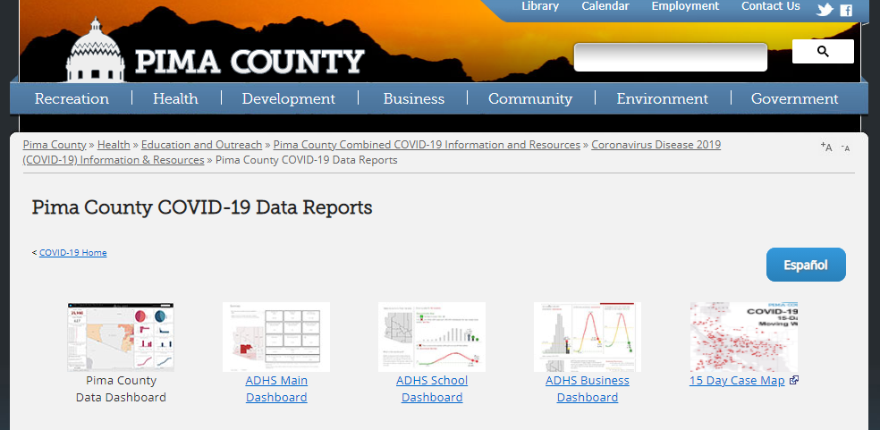
Pima County COVID-19 Data Reports
Data and statistics from the information gathered about COVID-19 cases in Pima County can help the public and health officials make decisions about how to respond to and prevent the spread of the disease.

How healthy IS PIMA COUNTY? - u.s. news AND WORLD REPORT
Overview of the health of Pima County. Includes factors such as housing, infrastructure, education, and overall health.

Health Data, Statistic, and Reports
Find data, statistics and reports on the most pressing health issues in Pima County, including:
Annual Medical Examiner Reports
County Health Reports and Plans
Substance Use
Influenza Data
BRFSS Annual Reports
Obesity Prevalence
HIV Reports
and more!

Arizona Department of Health Services
ADHS provides annual Excel spreadsheets of specific county-level data on:
Discharges of inpatients with fall injuries among Arizonans 65+
Inpatient discharges with fall injuries
Inpatient discharges and emergency room visits with fall injury
Inpatient discharges with hip fractures

Community Assessment Tool
Interactive data tool by the USDA to help community leaders build grassroots strategies to address the opioid epidemic. The tool allows users to create county-level maps illustrating the relationship between community and population demographics and fatal drug overdoses—including opioids—in the United States.
County Encyclopedia for Arizona (NEW)
New data system with data relating to Arizona county finances, demographics, districts, courts and some statewide and municipal information.
New for FY 2019 Update: Arizona Justice, Superior and Juvenile Court data, county transportation funding data, even more historic and current year data on already available subjects. You can also now view several different data points mapped across the state!

Small Area Income and Poverty Estimates
Available for roughly 3,141 counties, including Pima County, and over 13,222 school districts, these statistics represent the only current, single-year income and poverty statistics available for all counties and school districts. Data are provided on the total number of people, as well as the number of school-age children, and children of all ages, in poverty. An interactive map is also available. (2018 data release date: Dec. 3, 2018).
2018 data is available.

Youth Online
Youth Online lets you analyze national, state, and local Youth Risk Behavior Surveillance System (YRBSS) data from high school and middle school surveys conducted during 1991 – 2017 and Global School-based Student Health Survey (GSHS) data from students aged 13-17 conducted during 2003 – 2015. Youth data includes:
Unintentional Injuries and Violence
Tobacco Use
Alcohol and Other Drug Use
Sexual Behaviors
Dietary Behaviors
Physical Activity
Obesity, Overweight, and Weight Control
Other Health Topics

Study of Children Ages 10 to 17 (2016-17)
The National Survey of Children’s Health (NSCH) collects information on the health of children in the United States who are 0-17 years old. Parents or caregivers are asked to report their child’s height and weight, which can be used to calculate body-mass index (BMI) for children 10-17 years. To learn more about the 2016-17 youth obesity data, read the research brief.

Community Commons
Site allows you to build reports based on the data you selected. Data topics includes:
Equity - areas of ethnic diversity, vulnerable populations, equity user map, etc.
Economy
Education
Environment - air quality, physical environment, etc.
Food - food environment, supermarket locations, SNAP race/ethnicity, etc.
Health - uninsured, rural health clinics, mental health facilities, etc.
and more!

Arizona Environmental Public Health Tracking (EPHT) Explorer
Maps and datasets on a variety of topics included in the Environmental Public Health Tracking network.

The State of Obesity in Arizona
Data on Arizona youth and adult obesity as well as a listing of state policies to prevent obesity in Arizona schools, the community, and early childhood settings.

State Health System Performance
The State Health System Performance measures show how states serve Medicaid and CHIP beneficiaries in six areas:
Promoting communication & care coordination
Reducing harm in care delivery
Promoting prevention & treatment of chronic diseases
Strengthening engagement in care
Making care affordable
Working with communities to promote healthy living

City Health Dashboard
The dashboard was built to measure and compare health at the city level. The dashboard includes the following metrics:
Social and Economic factors
Physical Environment
Health Behavior
Health Outcomes
Clinical Care

Census Infographics & Visualizations
The Census Bureau Library collects more selectively in a variety of other fields, including:
Sociology (General)
Public Health
Economics, History, and Urban Studies
Ethnic Studies and Management
Additionally, the Library collects works that make extensive or innovative use of census-produced data. (See the full list of data tools).

Places For Bikes City Ratings system
National nonprofit advocacy group, People For Bikes, released a new, completely data-driven and transparent rating system to identify the best cities in the U.S. for bicycling. The leading cities were announced last week at the second annual Places For Bikes Conference that took place in Indianapolis, IN.
The City of Tucson was recognized for our score of 3.3. out of 5, which put us 2nd among big cities and 5th overall! A total of 484 cities were part of the analysis.
Additional links:

MAP Dashboard for Southern Arizona
Indicators that show Tucson's overall wellbeing and it how it compares to other Southwestern regions. Users will find data and analysis for 36 socio-economic indicators grouped into six categories:
Economy
Education
Health and Social Wellbeing
Quality of Place
Infrastructure
Workforce and Demographics

U.S. Eviction Rankings, Map and Data
The Eviction Lab at Princeton University released a new publicly available dataset with aggregated counts and rates of eviction filings and judgments across the United States. Data includes Arizona and Tucson, AZ specific data. The researchers sought landlord/tenant records from courts in each state and other data providers, removed irrelevant cases, and aggregated them into counts by state, county, and other geographic levels.

Arizona Community Data Portal
The CDP provides access to drug, crime, and criminal justice-related data for policymakers and practitioners through the use of a web-based data dissemination tool.
To watch a webinar or sign-up for a training on how to use the portal, please click here.

Tucson Crime Mapping
The CrimeReports.com site is updated nightly, and contains the most recent 6-months of crime and proactive-policing activity within Tucson. If you are in need of data that is older than the most recent 6-months or if you need data that is not available via the CrimeReports.com site, please contact the Tucson Police Department Records Section at (520) 791-4462 or by email at PDRecords@tucsonaz.gov.

Map the Meal Gap
Map the Meal gap analyzes the relationship between food insecurity and its determinants (poverty, unemployment, median income, etc.) at the state level, then using these data in combination with county level data, generates estimated food-insecurity rates for all individuals and for children at the county and congressional district levels. Data sources for Map the Meal Gap include: The Current Population Survey (CPS), the American Community Survey (ACS) and the Bureau of Labor Statistics (BLS).

U.S. Census Bureau’s Small Area Health Insurance Estimates program
The program produces the only source of data for single-year estimates of health insurance coverage status for all counties in the U.S. by selected economic and demographic characteristics.

Population Health and Vital Statistics
Hospital Inpatient Discharges & Emergency Room Visits Statistics:

AARP Livability Index
AARP, the American Association of Retired Persons, is an organization that has assumed a leadership role in identifying and describing what design elements of the physical environment contribute to healthy communities. AARP has partnered with a number of organizations such as the American Planning Association; the Robert Wood Johnson Foundation; and the American Public Health Association. One of their premier programs is the Livability Index.
The Livability Index is a signature initiative of the Public Policy Institute to measure the quality of life in American communities across multiple dimensions: housing, transportation, neighborhood characteristics, environment, health, opportunity, and civic and social engagement. An interactive, easily navigated website, the Livability Index allows users to compare communities, adjust scores based on personal preferences and learn how to take action to make their own communities move livable.

Behavioral Risk Factor Surveillance System (BRFSS)
The BRFSS survey is an annual state-wide survey of adults aged 18 years and older. The report summarizes data on health-related quality of life, preventative practices, barriers to healthcare, health risk behaviors, beneficial health practices, and health conditions and limitations as reported by Arizonans. The most recent report is from 2015.

CDC: Diagnosed Diabetes Prevalence
The CDC's County Data application allows you to view data and trends of diagnosed diabetes, obesity, and leisure-time physical inactivity at the national, state, and county levels. You will be able to access: 1) Arizona and Pima County 2013 data; 2) data on how Pima County compares with other counties, and 3) maps and motion charts to examine how changes in diabetes coincide with changes in obesity over time and by location. These data can help the public to better use existing resources for diabetes management and prevention efforts.

Arizona Department of Public Safety - Crime Reports
Provides data on the nature and extent of crime throughout Arizona. Key reports include:

Arizona Bicyclist and Pedestrian Crash Map, Facts and Reports
Data from the Arizona Department of Transportation (ADOT) that covers reported traffic collisions involving a bicyclist or a pedestrian. The underlying data comes from ADOT. Each year they release a public data set with codified information for each of the reported Motor Vehicle crashes. The data is also referred to as the ASDM (ADOT Safety Data Mart).
Data from the Tucson Police Department (TPD) on traffic incidents, updated nightly. Click the download button to download the most recent Excel spreadsheet of incidents.

Arizona Youth Survey
Covers the prevalence and frequency of substance abuse by youth, as well as their attitudes toward substance abuse at the county level.

Arizona Indicators
Arizona Indicators is a centralized data resource that provides extensive and accessible indicator data on:

Arizona Department of Liquor
List of liquor license applications for the state of Arizona
Can't find the data you need? Contact us at: HealthyPima@pima.gov